In the long term, floods kill more people in the United States than other types of severe weather. In recent years, only heat surpassed flood fatalities. Floods can roll boulders the size of cars, tear out trees, destroy buildings and bridges, and pose a significant threat to human lives.
”Flooding never happens here. Tom was trying to get home. He drives on the road near the stream every day. We knew it had been raining a lot, but it had been so dry, we were actually happy about the rain. Tom saw some water on the road, but thought it wasn't that deep. And, after all, he was in his truck, high up off the ground. But then his truck started to float, and before he knew it, his truck was washed downstream with him in it. Fortunately, his truck got stuck on a rock or something, and someone saw him and threw him a line. Tom got out okay. But we really learned from this, not to drive in floods.”
- Testimony of Marilyn and Tom (last name requested to be withheld)
Interviewed by the American Red Cross after Tropical Storm Allison struck Texas in June 2001
Once a river reaches flood stage, the flood severity categories used by the NWS include minor flooding, moderate flooding, and major flooding. Each category has a definition based on property damage and public threat.
The NWS characterizes flood severity to more effectively communicate the impact of flooding. It uses the following categories:
Minor Flooding - minimal or no property damage, but possibly some public threat or inconvenience.
Moderate Flooding - some inundation of structures and roads near streams. Some evacuations of people and/or transfer of property to higher elevations.
Major flooding - extensive inundation of structures and roads. Significant evacuations of people and/or transfer of property to higher elevations.
The impacts of floods stage associated with cooperation with local vary locally. For each NWS river forecast location, flood each of the NWS flood severity categories are established in public officials. Increasing river levels above flood stage constitute minor, moderate, and major flooding. Impacts vary from one river location to another because a certain river stage (height) above flood stage in one location may have an entirely different impact than the same level above flood stage at another location
A flash flood is a rapid rise of water along a stream or low-lying urban area. Flash flood damage and most fatalities tend to occur in areas immediately adjacent to a stream or arroyo, due to a combination of heavy rain, dam break, levee failure, rapid snowmelt, and ice jams. Additionally, heavy rain falling on steep terrain can weaken soil and cause mud slides, damaging homes, roads, and property.
Flash floods can be produced when slow moving or multiple thunderstorms occur over the same area. When storms move faster, flash flooding is less likely since the rain is distributed over a broader area.
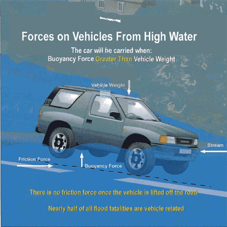
Almost half of all flash flood fatalities occur in vehicles. Contrary to popular belief, many people don’t realize two feet of water on a bridge or highway can float most vehicles. If the water is moving rapidly, the car, truck, or SUV can be swept off the bridge and into the creek.
Water can erode the road bed creating unsafe driving conditions. Underpasses can fill rapidly with water, while the adjacent roadway remains clear. Driving into a flooded underpass can quickly put you in 5-6 feet of water. Many flash floods occur at night when flooded roads are difficult to see.
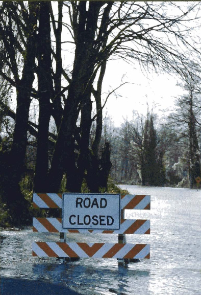
When you approach a flooded road, TURN AROUND DONT DROWN!
DO NOT DRIVE INTO A FLOODED ROADWAY
DO NOT DRIVE THROUGH FLOWING WATER
TURN AROUND AND DRIVE THE OTHER WAY
Since many flash floods occur along small streams, you can determine your risk by knowing your proximity to streams. Flooding can be caused by rain falling several miles upstream and then moving downstream rapidly.
Densely populated areas have a high risk for flash floods. The construction of buildings, highways, driveways, and parking lots increases runoff by reducing the amount of rain absorbed by the ground. This runoff increases the flash flood potential. Sometimes, streams through cities and towns are routed underground into storm drains. During periods of heavy rainfall, storm drains may become overwhelmed and flood roads and buildings. Low spots, such as underpasses, underground parking garages, and basements can become death traps.
Embankments, known as levees, are built along rivers and are used to prevent high water from flooding bordering land. In 1993, many levees failed along the Mississippi River, resulting in devastating flesh floods.
Dam failures have played a deadly role in the history of flash flooding. The United States has about 76,000 dams, and about 80 percent of those are of earthfill construction. Be aware of any dams upstream of your location. Earthen dams are more easily compromised by heavy rainfall than are concrete structures. Water flowing over an earthen dam can cause the dam to weaken or fail, sending a destructive wall of water downstream
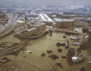
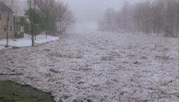
Major flooding from Tropical Storm Allison in Houston,
Texas, June 2001. Photo: Harris county Flood Control
District, Houston, Texas.
Many people enjoy hiking, fishing, or camping along streams and rivers. Listen to weather forecasts and keep away from streams if thunderstormar have happened or have been predicted upstream from where you are. A creek only 6 inches deep in mountainous areas can swell to a 10-foot deep raging river in less than an hour if a thunderstorm inundates the area with intense rainfall.
When thunderstorms are in the area, stay alert for rapidly changing conditions. You may notice the stream start to rise quickly and become muddy. You may hear a roaring sound upstream that may be a flood wave moving rapidly toward you. Head immediately for higher ground. Don't be swept away by the rising water. Them am dangers associated with fast-moving water, but with common sense and some preparation, outdoor enthusiasts can enjoy a safe day along a stream or river.
May 31, 1889
A dam above Johnstown, PA, failed sending a huge flood wave through the city, killing 2,200 residents.February 26, 1972
The Buffalo Creek Dam, located in southern West Virginia, collapsed sending a black wave of water through one coal mining town after another killing more than 100 people and leaving 4,000 people homeless.July 31, 1976
Big Thompson Canyon Flash Flood resulted in 145 deaths. A storm dumped a foot of rain into the canyon, producing a raging torrent of water 19 feet high.- Source: National Weather Service
LISTEN for roaring sound upstream as flood waters could be headed your way!
LOOK for rapidly rising water and/or water turning muddy!
REMEMBER to climb to safety if you hear or see signs of a flood!
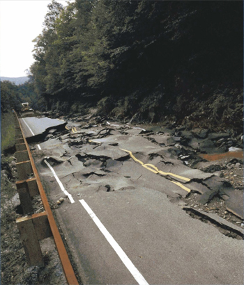
Road damage as a result of flash flooding.
Photo: Steve Allen Photography, Waitsfield, VT.
Mountains and steep hills produce rapid runoff and quick stream response. Rocks and clay soils do not allow much water to infiltrate the ground. Steep narrow valleys generate rapid flowing waters that can rise quickly to a considerable depth. Saturated soil also can lead rapidly to flash flooding.
Very intense rainfall can produce flooding even on dry soil. In the West, most canyons and "small streams" are not easily recognizable as a source of danger. Canyons can be scoured with sudden walls of water 10-15 feet high (e.g., Antelope Canyon, Arizona, August 1997, 11 fatalities).
Additionally, high risk locations include low water crossings, recent burn areas in mountains, and urban areas from pavement and roofs which concentrate rainfall runoff.
PERSISTENT THUNDERSTORMS OVER THE SAME GEOGRAPHICAL AREA CAN LEAD TO RIVER FLOODING.
A flood is the inundation of a normally dry area caused by an increased water level in an established watercourse. River flooding is often caused by:
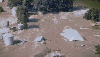
River flooding due to exessive rain.
Photo: Jim Rackwitz, St. Louis Post-Dispatch
River flooding due to ice jam.
Photo: Steve Allen Photography
Floods are often produced by hunicanes, tropical storms, and tropical depressions. A tropical cyclone's worst impact may be the inland flooding associated with torrential rains.
When these storms move inland, they are typically accompanied by very heavy rain. If the decaying storms move slowly over land, they can produce rainfall amounts of 20 to 40 inches over several days. Widespread flash flooding and river flooding can result from these slow-moving storms.
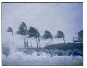
A hurricane also can produce a deadly storm surge that inundates coastal areas as it makes landfall. Storm surge is water pushed on shore by the force of the winds swirling around the storm. This advancing surge combines with the normal tides to create the hurricane storm tide, which can increase the average water level 15 feet or more.
The worst natural disaster in the United States, in terms of loss of life, was caused by a storm surge and associated coastal flooding from the great Galveston, Texas, hurricane of 1900. At least 8,000 people lost their lives.
FLOODS ARE LONG TERM EVENTS AND MAY LAST DAYS, WEEKS, OR LONGER!
Deaths from hurricane coastal flooding have fallen dramatically in recent years, but storm surge remains a great threat.
"50% of deaths associated with tropical cyclones are a result of inland flooding over the last 30 years."
-Ed Rappaport, National Hurricane Center
1972
Hurricane Agnes
122 deaths
Agnes produced floods in the northeast United States contributing to $6.4 billion in damages.
1994
Tropical Storm Alberto
33 deaths
Alberto drifted over the southeast United States producing torrential rainfall and drowning 33 people. Damages exceeded $750 million dollars.
1999
Hurricane Floyd
56 deaths
Floyd brought intense rains and record flooding to the eastern United States. Of the 56 people who perished, 50 drowned from inland flooding.
2001
Tropical Storm Allison
44 deaths
Allison flooded the coastal sections from the Gulf Coast to New England. More than 3 feet of rain was reported along the Gulf Coast.
Listen to National Oceanic and Atmospheric Administration (NOAA) Weather Radio All Hazards, commercial radio, or television; or go to the lnternet for the latest flash flood and flood watches, warnings, and weather advisories at:
http://iwin.nws.noaa.gov/iwin/nationalwarnings.html
For planning purposes, Flood Hazard Map information is only a click away by going to the Federal Emergency Management Agency web page at:
http://www.fema.gov/national-flood-insurance-program-flood-hazard-mapping
AHPS of the National Weather Service provides improved river and flood forecasting and water information. AHPS has a suite of graphical lnternet products to assist community leaders and emergency managers in making better life- and cost-savings decisions about evacuating people and moving property before a flood occurs.
AHPS major themes:
According to the National Hydrologic Warning Council report, "Use and Benefits of the National Weather Service River and Flood Forecasts," AHPS, once fully implemented throughout the United States, will provide more than $750 million in economic benefits each year.
Additional AHPS information can be obtained at:
http://water.weather.gov/ahps/
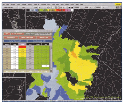
AHPS Weather Display. Source: National Weather Service
Use NOAA Weather Radio All Hazards!
NOAA Weather Radio All Hazards is the best way to receive warnings from the National Weather Service. NOAA Weather Radio All Hazards is a nationwide network of radio stations broadcasting continuous weather information direct from a nearby National Weather Service office.
NOAA Weather Radio All Hazards broadcasts National Weather Service warnings, watches, forecasts, and other hazard information 24 hours a day. The average reception range is a 40-mile radius from the transmitter, depending on topography. Be aware of the potential for flooding before the heavy rainfall begins by listening to NOAA Weather Radio All Hazards.
Purchase a NOAA Weather Radio All Hazards that has a battery back-up, a Specific Area Message Encoder (SAME) feature, which automatically alerts you when a Watch or Warning is issued for your county or parish, and one that can receive all seven NOAA Weather Radio frequencies. NOAA Weather Radio All Hazards can also broadcast post-event information for all types of hazards-both natural (earthquakes, hurricanes and volcanos) and environmental (chemical or oil spills).
The NOAA Weather Radio All Hazards network has more than 650 transmitters, covering the 50 states, adjacent coastal waters, Puerto Rico, the U.S. Virgin Islands, and the U.S. Pacific Territories. NOAA Weather Radio requires a special radio receiver or scanner capable of receiving the signal. Broadcasts are found in the public service band at these seven frequencies (MHz): 162.400, 162.425, 162.450, 162.475, 162.500, 162.525, 162.550 (also known as channels 1 through 7).
NOAA Weather Radio All Hazards requires a special radio receiver or scanner capable of picking up the signal. These receivers can be purchased at retail electronic and sporting good stores.
NOAA Weather Radio Bands: Channel Frequencies (MHz)
1 162.400
2 162.425
3 162.450
4 162.475
5 162.500
6 162.525
7 162.550
TO HELP AMERICA PREPARE FOR THE RAVAGES OF FLASH FLOODS AND FLOODS, THE NATIONAL WEATHER SERVICE HAS DESIGNED STORMREADY, TO ARM AMERICA'S COMMUNITIES WITH THE COMMUNICATION AND SAFETY SKILLS NECESSARY TO SAVE LIVES AND PROPERTY. MORE INFORMATION IS AVAILABLE AT: http://www.nws.noaa.gov/stormready/
After you have developed a personavfamily safety plan, find out about your community safety plan. Each community prone to a flash floodlflood should develop a safety plan. Local officials should have detailed information for your immediate area. Please listen and follow their recommendations before, during, and after a storm.
The best way to prevent loss of life is to design and build communities where roads I remain usable and undamaged during floods, and where homes and businesses are protected. While this may not always be possible, it is a goal we hope every community strives to reach.
Protect yourself, your home, your family, and your financial future.
One of the most important things you can do to protect your home and family before a flood is to purchase a flood insurance policy. You can obtain one through your insurance company or agent. Your agent can tell you whether the standard or preferred policy (for medium or low risk) is most appropriate for you. Flood insurance is backed by the National Flood lnsurance Program (NFIP), administered by the - Federal Emergency Management Agency. Your homeowners insurance does not cover flood damage. Everyone has some flood risk and anyone in a participating community is eligible. Don't wait until a flood is coming to purchase your policy. It normally takes 30 days after purchase for a flood insurance policy to go into effect. For more information about the NFlP and flood insurance, contact your insurance company or call the NFlP at 800.427.4661.
Check with your city or county government (start with the Building or Planning Office) to find out if you live in a participating community and what flood risk information is available where you live.
Contact your local emergency management agency or local National Weather Service office for further information on Local Flood Warning Systems, or visit:
http://www.nws.noaa.gov/os/water/resources/Flood_Warning-Systems_Manual.pdf
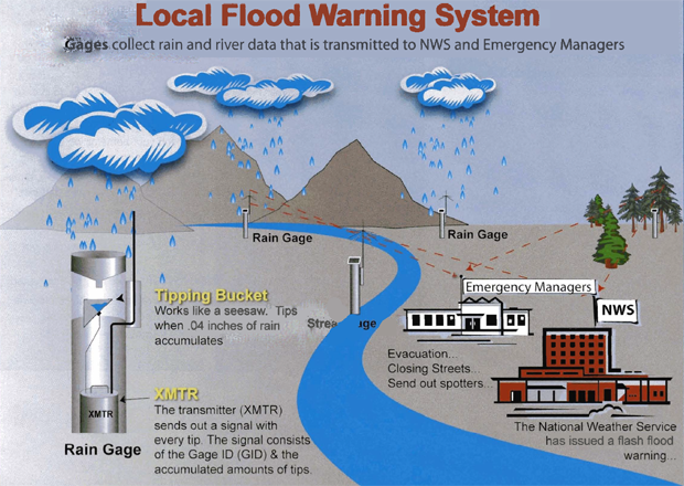
National Weather Service forecasters rely on a network of almost 10,000 streamgages to monitor the height of rivers and streams across the Nation. This information provides present river conditions and is the initial information needed to develop a river forecast. Most of the streamgages are maintained by the U.S. Geological Survey, the U.S. Army Corps of Engineers, and the Department of Agriculture. Some streamgages are read manually by dedicated volunteer observers. If you would like to volunteer as a cooperative observer, visit the web site at: http:Nwww.nws.noaa.gov/om/coop/become.htm
Many communities nationwide have partnered with the National Weather Service and other federal agencies (e.g., U.S. Geological Survey and the U.S. Army Corps of Engineers) to implement dense networks of precipitation gages and streamgages to monitor and detect flooding in their community. These networks are often referred to as Local Flood Warning Systems.
NATIONAL WEATHER SERVICE FORECASTERS RELY ON A NETWORK OF ALMOST 10,000 STREAMGAGES TO MONITOR THE HEIGHT OF RIVERS AND STREAMS ACROSS THE NATION
When you receive a Flood Watch:
MYTH A 100-year flood occurs only once every 100 years. |
FACT The 100-year flood is a climactic average; there is a 1% chance that a 100-year flood will occur in any given year. |
MYTH Flash floods mainly occur in the eastern United States. |
FACT Flash floods occur in all 50 states, inclusing Alaska and Hawaii |
MYTH Flash floods occur only along flowing streams. |
FACT Flash floods can occur in dry arroyos and urban areas where no streams are present. |
MYTH Flash floods occur mainly in the late afternoon and evening. |
FACT Many flash floods occur at night. |
MYTH Homeowners insurance policies cover flooding. |
FACT Unfortunatley, many homeowners do not find out until it is too late that their policies do not cover flooding. Contact your insurance company or agent to buy flood insurance. |
MYTH You can't buy flood insurance if your property has been flooded. |
FACT You are still eligible to purchase flood insurance after your home, apartment, or business has been flooded, provided your community is participating in the National Flood Insurance Program. |
MYTH Larger vehicles, such as SUVs and pickups, are safe to drive through flood waters. |
FACT Two feet of rushing water can carry away most vehicles including SUVs and pickups. |
DURING A FLOOD WARNING, DON'T DRIVE WHENEVER POSSIBLE!
When you receive a Flood Warning:
Contact your local National Weather Service office, emergency management office, and American Red Cross chapter. Find out what types of disasters could occur and what you should do. Learn about your community's methods of warning people and evacuation plans. Ask your insurance agent about flood insurance. Find out what you can do to protect your home from the effects of natural hazards that could occur where you live. Meet with your family to create a plan.
Discuss the information you have gathered. Pick two places to meet: a spot outside your home for an emergency such as a fire, and a place away from your neighborhood in case you can't return home. Choose an out-of-town family member or friend as your family check-in contact for everyone to call if the family gets separated, and a backup out-of-neighborhood friend in case the first one does not answer. Discuss what you would do and how tp dp ot of advised to evacuate.
For More Information:
Contact your local National Weather Service (NWS) office, American Red Cross chapter or local emergency management agency for more weather-related brochures.
You can find more information on flash flooding in the Floods… The Awesome Power brochure. Contact your local Red Cross chapter or NWS office for copies. You can download a copy at this NWS Web site http://www.nws.noaa.gov/om/water/ahps/pdfs/Floodsbrochure_02_06.pdf. To find additional materials on winter safety, try the following Web sites:
NWS: www.nws.noaa.gov
FEMA: www.fema.gov
Red Cross: www.redcross.org
U.S. Department of Commerce
National Oceanic and Atmospheric Administration
NOAA's National Weather Service

ARC 4467 June 2008 NOAA/PA 200160
Publication #: ARC 4493 NOAA/PA 200467 March 2005
Disclaimer and Reproduction Information: Information in NASD does not represent NIOSH policy. Information included in NASD appears by permission of the author and/or copyright holder. More
